Half Marathon (HM)
Overview
| Distance: | 21.2 km | |
| Start location: | Oberhof Tambacher Strasse street towards Grenzadler |
|
| Start time: | from 7:30 a.m. (in starting blocks) | |
| Finish location: | Schmiedefeld am Rennsteig (711 m above sea level) | |
| Finish closing time: | 11:00 a.m. | |
| Entry fee: | Graduated price scale as per Race Announcement Dates: by 31 Oct / 31 Mar / 17 May |
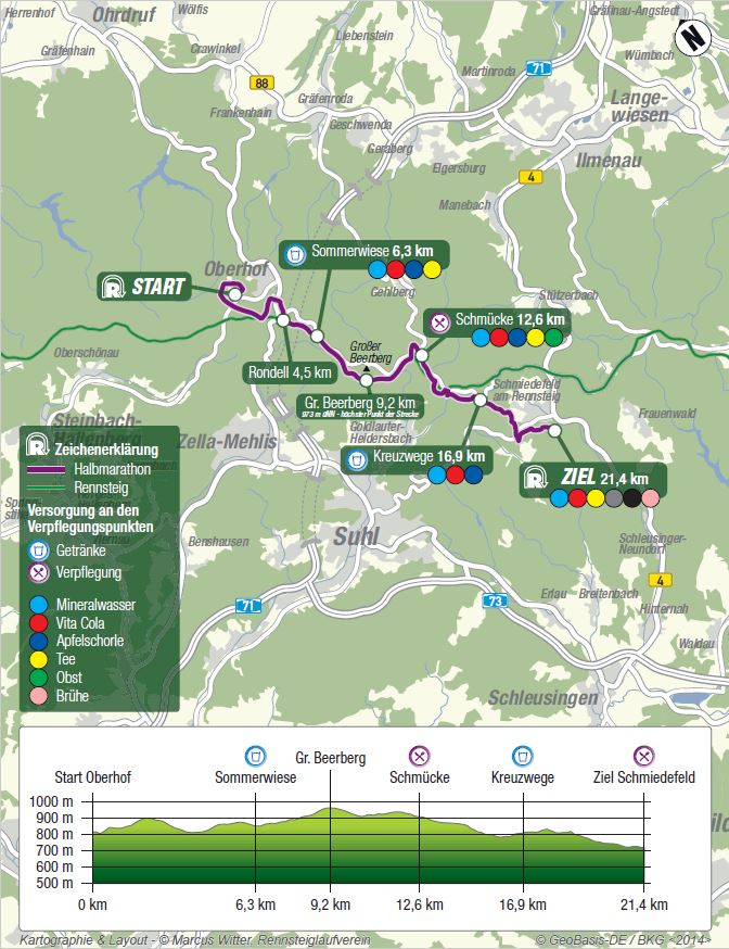
Course Map
Download
Halfmarathon Course Map
![]()
Details and Profile / Outdooractive
Course Description
The start area is in Tambacher Strasse street towards Grenzadler and the start line is at the level of the Rennschlitten Bobbahn luge and bobsleigh run. WSRO – Skisport GmbH has taken charge of the organisation at the start location.
As there is a large number of participants, the race will be started in a block arrangement. The block assignment will be done by the event organiser on the basis of previous-year times achieved and will be colour coded on each runner’s bib number.
At 7:30 a.m. sharp, the large field of runners will set out onto the course. Block after block will pass over the starting mats which measure the personal start time for every runner.
From the start the race follows the road, passing the luge run, the skiing hall and the biathlon stadium, then turning left onto the Rennsteig trail after 1 km at Grenzadler. Next is an uphill stretch towards Stein 16 (km 2.6), where the course briefly leaves the Rennsteig again and leads back through Harzwald forest to the outskirts of Oberhof. Returning along Waldstrasse and Zellaer Strasse streets and underneath the B247 trunk road to the Rondell (km 4.8 / 826 m), the race is back on the original course and on the Rennsteig. There follows the first short uphill to “Sommerswiese” (km 6.5 / 859 m), where participants cross the road and start the climb towards “Großer Beerberg”. The highest elevation of the course is reached just below the top of Großer Beerberg at “Plänckners Aussicht” (km 9 / 969 m). The race goes on passing “Adler” (km 10 / 934 m) and then “Rosenkopf” (km 10.5 / 937 m) on the way to the aid station at “Schmücke“ (km 12.1 / 912 m), which is set up by SWV Goldlauter skiing and hiking club.
Along the Rennsteig the route reaches “Borstenplatz” (km 13 / 879 m), where it moves away from the Rennsteig and leads around Goldlauterberg hill to arrive 1.5 km further on at “Mordfleck” (km 14.1 / 825 m). At this point the race departs to the right from the high route of the Thuringian Forest and continues underneath the Mordfleckswand face to “Bierfleck” (Kreuzwege – km 16.55 / 822 m). Now, past the Schmiedefeld ski slope, across the road and then the finish location is almost reached. The race passes all the way through the garden area along a narrow tarred road towards the finish on the Schmiedefeld sports ground (km 21.1 / 711 m). This is where the team of the local WSV Schmiedefeld winter sports club together with spectators and support teams will be waiting from 8:30 a.m. for the incessant flow of half marathoners whose crossing the finish line brings about the buzz at the place on this day.
Elevation Difference
| Total uphills: | 293 m | |
| Total downhills: | 419 m | |
| Elevation difference: | 712 m | |
| Highest location: | Plänckners Aussicht (973 m above sea level) | |
| Lowest location: | Finish line at Schmiedefeld (711 m above sea level) |
Register Online
Please read the respective Race Announcement before registering!


